Understanding winds aloft forecasts: A guide for aviators
Published Sunday, July 13, 2025
Winds aloft forecasts are essential for pilots and aviation professionals to plan safe and efficient flights. This guide explains what winds aloft forecasts are, how they are created, and how to interpret the coded data they contain. Understanding these forecasts is crucial for flight planning, as winds at different altitudes significantly impact aircraft performance, navigation, and potential weather hazards.
Summary:
- What are winds aloft forecasts?
- How winds aloft forecasts are created
- Interpreting winds aloft forecasts
- Importance of winds aloft in aviation
What are winds aloft forecasts?
Components of winds aloft forecasts
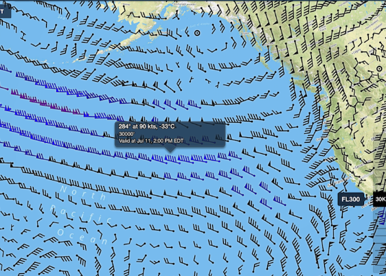
Winds aloft forecasts contain several critical components for aviation. The key elements are wind direction, wind speed, and temperature at specific altitudes.
Wind direction is indicated in degrees relative to true north. Wind speed is provided in knots. These two factors together paint a picture of the wind conditions that aircraft will encounter at various flight levels.
Temperature is also included, typically in degrees Celsius, as it impacts aircraft performance. Colder temperatures at higher altitudes affect air density and engine efficiency.
Aviators rely on these core components of winds aloft forecasts for flight planning. Anticipating winds and temperatures at cruise levels is essential for calculating groundspeed, fuel burn, and potential turbulence. By carefully evaluating this data, pilots and dispatchers optimize routes for safety, comfort and efficiency.
Altitude levels in forecasts
Winds aloft forecasts provide wind data at various altitudes crucial for aviation. These altitudes are typically reported in feet above mean sea level (MSL), but there is an important distinction between true altitude and pressure altitude.
True altitude is the actual height above mean sea level. Pressure altitude is the height indicated by a pressure altimeter when set to a standard atmospheric pressure. At lower altitudes, up to about 18,000 feet MSL, winds aloft forecasts report true altitudes.
However, at higher altitudes of 18,000 feet and above, the forecasts switch to using pressure altitudes, often expressed as flight levels (FL). For example, FL300 represents a pressure altitude of approximately 30,000 feet. This change is made because aircraft at these higher altitudes fly at constant pressure levels for more efficient air traffic management.
Pilots must be aware of these differences and properly interpret the winds aloft forecast for their planned altitude, whether using true altitude or pressure altitude references. Setting the correct altimeter reference is essential for accurate navigation and maintaining safe separation from other aircraft, especially when transitioning between high and low altitude flight.
How winds aloft forecasts are created
Data collection methods
Several techniques are used to gather wind data at various altitudes:
- Radiosondes: Weather balloons carrying instrument packages called radiosondes are launched twice daily from sites worldwide. As they ascend, radiosondes transmit data on wind speed, direction, temperature, humidity, and pressure.
- Satellites: Wind conditions can be inferred by tracking the movement of clouds in satellite imagery. This method provides broad coverage, especially over oceans where other observations are sparse.
- Aircraft reports: Many commercial airliners are equipped to measure winds encountered during flight. This data is relayed via datalink to ground stations, providing valuable real-time wind information along flight routes.
- Remote sensing: Technologies like Doppler radar and lidar can measure winds by analyzing the motion of air particles or clouds. While not as widespread as radiosondes, these systems offer continuous wind profiling at specific locations.
- Weather models: Supercomputers process wind observations from various sources to generate forecast models. These numerical models simulate atmospheric dynamics to predict wind patterns at different altitudes over time.
By integrating data from these diverse methods, meteorologists build a comprehensive picture of winds aloft. This information is critical for aviation flight planning and weather forecasting.
Forecast modeling and computation
The wealth of wind and temperature data gathered through various collection methods serves as the foundation for generating accurate winds aloft forecasts. However, transforming this raw information into meaningful predictions requires the power of advanced meteorological algorithms and supercomputer processing.
Collected data from weather balloons, satellites, aircraft reports, and remote sensing technologies is fed into sophisticated numerical weather prediction models. These complex algorithms simulate the dynamics of the atmosphere, taking into account factors such as pressure gradients, air density, and the influence of terrain on wind patterns.
Running on supercomputers, the models crunch vast amounts of data to generate detailed winds aloft forecasts for different altitudes and locations. By continuously assimilating the latest observations, the models can update their predictions, ensuring that aviators have access to the most current and accurate information for flight planning. This symbiosis between cutting-edge data collection, powerful computing, and intricate meteorological algorithms forms the backbone of reliable winds aloft forecasts in modern aviation.
Update frequency and forecast validity
Winds aloft forecasts are typically updated four times per day, based on observations taken at 00Z, 06Z, 12Z, and 18Z. This regular update cycle helps ensure that aviators have access to the most current wind and temperature data for flight planning.
However, it's important to understand the valid time periods for these forecasts. The forecasts issued at 00Z and 12Z are valid for 6, 12, and 24 hours after the observation time. For example, a forecast based on the 00Z observations would be valid for the periods 06Z-12Z (FD1), 12Z-18Z (FD2), and 00Z-24Z the following day (FD3).
Aviators must carefully consider these valid times when planning flights, especially longer journeys. While winds aloft forecasts provide critical information, the dynamic nature of the atmosphere means that actual conditions can change between updates. Pilots should supplement winds aloft data with other weather resources and remain vigilant for any significant changes that may affect their flight.
Interpreting winds aloft forecasts
Decoding forecast formats
Winds aloft forecasts present wind and temperature data in a coded format. Wind direction is indicated in tens of degrees relative to true north. For example, "31" represents a wind direction of 310 degrees.
Wind speed directly follows the direction and is given in knots. A forecast of "3127" decodes as wind from 310 degrees at 27 knots.
Temperatures above 24,000 feet are presented after the wind group, with the +/- sign omitted as values are assumed negative. "731960" translates to wind from 230 degrees at 119 knots with a temperature of -60°C.
Special coding is used for winds 100 knots or greater. 50 is added to the direction and 100 subtracted from the speed. "770799" decodes as wind from 270 degrees at 199 knots or greater.
Light and variable winds under 5 knots are coded as "9900". Understanding this format is key to extracting critical wind and temperature information for flight planning.
Special coding for high wind speeds
When wind speeds in a forecast exceed 99 knots, a special coding system is used. 50 is added to the wind direction and 100 is subtracted from the wind speed.
For example, a forecast of "731960" would be decoded as follows:
- Step 1: 73 - 50 = 23 (230°)
- Step 2: 19 + 100 = 119 knots
So "731960" translates to a wind from 230° at 119 knots, with a temperature of -60°C.
In cases where the wind speed is forecast to be 200 knots or greater, the wind group is coded as 99 knots. A forecast of "189960" decodes as a wind from 180° at 200+ knots, with a temperature of -60°C. This special encoding allows winds aloft forecasts to convey extremely high wind speeds that may be encountered by aircraft at higher altitudes using the standard format.
Using winds aloft information in flight planning
Winds aloft forecasts are a critical tool for pilots and flight dispatchers in planning safe and efficient flights. The wind speed and direction at different altitudes directly impact an aircraft's groundspeed, fuel consumption, and estimated flight time.
By carefully analyzing winds aloft data, flight planners can optimize routes to take advantage of favorable tailwinds or avoid strong headwinds. This allows them to select the most fuel-efficient altitudes and minimize flight time. Dispatchers also use this information to calculate precise fuel requirements, ensuring aircraft carry sufficient fuel reserves.
In addition to route planning, winds aloft forecasts help pilots anticipate potential turbulence and plan for smoother flights. Areas of strong wind shear or significant changes in wind speed and direction with altitude can indicate possible turbulence. Armed with this knowledge, pilots can request altitude changes to mitigate passenger discomfort and ensure a safer flight.
Importance of winds aloft in aviation
Impact on aircraft performance
Winds aloft significantly affect an aircraft's speed over the ground and fuel efficiency. A strong headwind reduces groundspeed, increases flight time, and burns more fuel. However, a tailwind boosts speed, reducing flight duration and fuel consumption.
For example, a 100-knot headwind on a 1,000-nautical mile flight in a light jet cruising at 400 knots would increase flight time by 30 minutes and burn 20% more fuel compared to still air. Conversely, the same tailwind saves 30 minutes and 17% in fuel.
Carefully analyzing winds aloft allows pilots to select the optimum altitude, providing the best winds for the route. This maximizes performance and minimizes operating costs, a key consideration for business and private aviation.
Navigation and route planning considerations
Winds aloft can significantly impact flight times and fuel consumption. Strong headwinds reduce groundspeed and increase flight duration, while tailwinds provide a boost.
By carefully analyzing winds aloft forecasts, pilots can optimize their routes. Choosing altitudes with the most favorable winds allows them to minimize flight time and save fuel. Dispatchers also use this data to precisely calculate the required fuel, ensuring sufficient reserves.
In addition, pilots examine wind forecasts to anticipate potential turbulence. Significant changes in wind speed or direction at different altitudes may indicate turbulence. With this knowledge, pilots can request altitude changes for a smoother, safer flight for passengers and crew.
Weather hazards related to winds aloft
High-altitude winds can pose significant hazards to aircraft. Clear air turbulence (CAT) is one common danger, caused by wind shear between fast-moving air currents like the jet stream. CAT can strike suddenly in clear skies, jolting the aircraft and potentially injuring passengers or crew.
Wind shear, which is a sudden change in wind speed or direction, is another hazard associated with winds aloft. Encountering strong wind shear during takeoff or landing can dramatically impact lift, making it difficult to control the aircraft. Pilots must be alert for wind shear warnings and be prepared to quickly adjust airspeed and flight path.
Careful flight planning is essential to mitigate these risks. Pilots should closely review winds aloft forecasts, paying special attention to areas of predicted turbulence or wind shear. Choosing optimal altitudes and routing to avoid the worst conditions can greatly enhance safety and passenger comfort. In the air, pilots must remain vigilant, be ready to request altitude changes if needed, and keep passengers informed of any expected turbulence.
Understanding winds aloft is critical for aviation safety and efficiency. By carefully analyzing wind speed, direction, and temperature at various altitudes, pilots can optimize flight routes, anticipate weather hazards, and ensure the smoothest possible journey for passengers and crew. With advanced data collection methods and powerful computer modeling, today's winds aloft forecasts provide aviators with the insights they need to navigate the skies with confidence.
Book a private flight
With Orizair, discover hundreds of available flights to reach your destination the green way.
Find your destinationAt Orizair, we integrate sustainability into private aviation by automatically offsetting the carbon emissions of every flight and collaborating with committed partners like Treesition. Discover our commitment.